Continuous basin surveillance
Weekly multispectral satellite sweeps flag anomalies across entire river stretches, not just lease boundaries, so unauthorized activity is detected at the source.
Detect, verify, and prove illegal riverbed sand extraction at basin scale using a layered workflow: weekly satellite alerts -> 0.5 m verification -> drone volumetrics -> LiDAR forensic audits.
Traditional approaches focus on transport gates and weighbridges. This framework adds basin-wide source monitoring to detect extraction at the river itself, then escalates only the highest-probability targets to expensive ground assets.
Weekly multispectral satellite sweeps flag anomalies across entire river stretches, not just lease boundaries, so unauthorized activity is detected at the source.
0.5 m satellite imagery confirms flagged sites; drone photogrammetry computes extracted volume and compares it against permitted limits to quantify violations.
cm-level LiDAR audits provide tamper-proof, courtroom-grade depth proof. Every alert is traceable end-to-end: satellite -> drone -> LiDAR -> penalty.
Cameras see the road, not the river. Illegal excavation often happens outside lease areas, hidden by bends, vegetation, or temporary access roads. Without source monitoring, enforcement becomes reactive and disputable.
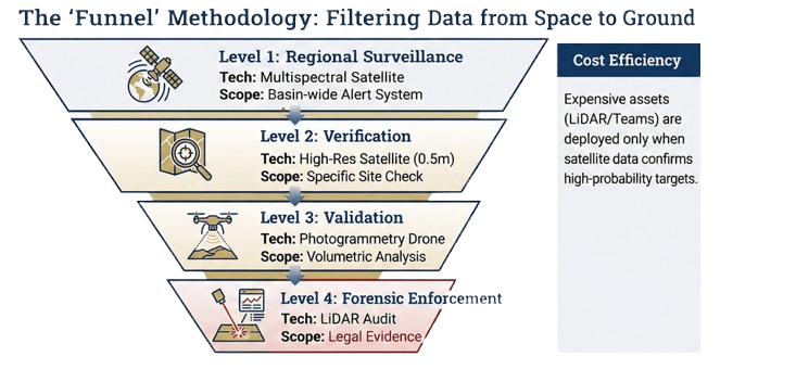
A cost-efficient method that moves from wide coverage to courtroom-grade proof.
Satellite indices flag "green / minor variance / high-probability anomaly" zones and detect new access tracks and turbidity.
Confirm suspected excavation and stockpiles with targeted high-res imagery before deploying field assets.
Compute extracted volume and compare with permitted limits to quantify violations.
Centimeter-level "bare earth" models provide tamper-proof depth proof, even through vegetation, for legal enforcement.
Deploy as a pilot cluster and scale statewide through phased rollouts.
A "digital handshake" between transport permitting and source monitoring.
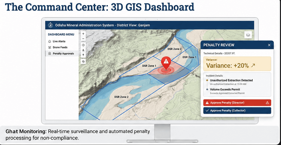
Real-time dashboard for hotspots, variance, and action queues.
Pre-monsoon vs post-monsoon surveys plus replenishment modelling for sustainable extraction limits.
Transparency that improves compliance and reduces disputes.
Automate recovery with standardized, defensible proof.
Extend monitoring beyond the ghat to detect hidden activity.
Start with a pilot cluster, then expand district-wide and statewide.
Deploy a pilot in priority basin stretches, validate DSR, calibrate satellite alerts, and establish volumetric baselines.
Scale drone teams, integrate collectorate workflows, and operationalize evidence-pack generation and penalties.
Full API link with i4MS, statewide dashboard, automated compliance reporting, and continuous replenishment monitoring.
Share your basin, current monitoring setup, and enforcement challenges. We'll respond with a pilot plan, dataset requirements, and an implementation schedule.
Want a faster start?
Upload your lease KML/KMZ plus a sample DSR/SoI to accelerate pilot design.